

SITE LOGIN
-
REVIEWS
- Ski Gear
- Clothing
- Accessories
- Off-Season Gear
- Lifestyle
- Lodges and Accommodation
- Nutrition
- Manufacturers
- Destinations
- Training
- Gear of the Year
- Best New Summer Gear
-
Holiday Gift Guide
-
Holiday Gift Guide 2024
- Holiday Gift Guide 2024 Base Layers
- MSR Explore Revo Snowshoes
- Fieldsheer Backcountry Heated Jacket
- Fieldsheer Premium 2.0 Merino Heated Socks
- MEC Hut Booties and Slippers
- Arc’teryx Kopec GTX Shoe
- Arc’teryx Kragg Insulated Approach Shoes
- Gregory Verte 18 Backpack
- Grundens Deck-Boss Ankle Boot
- MEC Northern Light Vest
- Montec-Scope-Ski-Goggles
- Mountain Hardware Kor Airshell Hoody
- Mountain Hardware Kor Alloy Crew
- Arcade Atlas Belt
- Dynafit Ridge Dynastretch Jacket
- Shokz OpenRun Pro 2 headphones
- Buff Merino Move Multifunctional Neckwear
- Bootdoc Foot Warmer
- Cotopaxi Allpa 42L Travel Pack
- DPS LastBag
- DPS PHANTOM Glide At-Home Kit
- DPS Mission Quiver Roller
- Dragon Amped sunglasses
- Dragon DX3 Plus OTG photochromic goggle
- Fuse Lenses Anclote Flashback
- Garmin Fenix 8 Solar Sapphire Watch
- Gregory Alpaca Gear Tote 30
- Hotronic Boot Dryer
- MEC Aluminum Pot Set
- Gnara Go There Pants
- Grundens Shackleton 2.0 Duffel
- Jones Deeper 19L Backpack
- Le Bent Core Midweight Crew base layer
- Leatherman ARC
- Montane Nordes Hooded Softshell Jacket and Pants
- Helly Hansen Odin Everdown Hooded Jacket
- Helly Hansen Verglas Infinity Shell Jacket 2.0
- Montec Fawk Ski Jacket
- Pomoca Free Pro 2.0 Skins
- Rab Glaceon Pro Down Jacket
- Rab Khroma Converge GORE-TEX Ski Jacket & Pants
- Smith Squad MAG Goggles
- Stellar Guide Aerogel Hybrid Hood 2.0
- Stellar Ultralight Down Hood 2.0
- Arms of Andes Alpaca Half Zip & Wool Leggings
- Cotopaxi Allpa 70L Duffel Bag
- Giro Taggert Mips Helmet
- Loonr Hi Flyer Boots
- Paka Mountain Crew
- Roll Recovery SUPERPLUSH Classic Shoes
- Smartwool Smartloft Hooded Jacket and Pants
- Ortovox Switchback 32 Ski Touring Backpack
- Cotopaxi Allpa X 3L Hip Pack
- Giro Sagen Ski Goggle
- Icebreaker Ski+ Over the Calf Socks
- MEC-Fireside-Fleece-Snap-Pullover
- Montec Roast Mittens
- Mountain-Hardware-Sunblocker-Hoody
- MSR Titan Kettle 900 ml
- Tailgate-Industries-The Gondom-Goggle-Cover
- Wild Country Rope Tarp
- Bootdoc Race Merino PFI 50 Socks
- Remind Soles Destin Impact Insoles
- Kari Traa Rose Baselayer Half Zip Top and Pants
- Le Bent Midweight Quarter Zip
- Ombraz Dolomite Sunglasses
- Ortovox Fleece Rib Hoody
- Ortovox Merino Thermovent Base Layer
- Smartwool Intraknit Merino Tech Half Zip
- Suunto Wing Bone Conduction headphones
- Sweet Protection Adapter Mips Helmet
- Sweet Protection Connor Rig Reflect Goggles
- Zeal Optics Selkirk Glacier Glasses
- Norrona more flex1 Pants
- Norrona Octa Zip Hood
- Norrona Lyngen Alpha100 Zip Hood
- MEC Deluxe Pillow
- Holiday Gift Guide 2023
- Holiday Gift Guide 2022
- Holiday Gift Guide 2021
- Holiday Gift Guide 2020
- Holiday Gift Guide 2019
- Holiday Gift Guide 2018
- Holiday Gift Guide 2017
- Holiday Gift Guide 2016
-
Holiday Gift Guide 2024
- Pro Skier Interviews
- NEWS
- STORE
- ROUTES
- LODGING
-
VIDEOS
- 2022/23 Gear Reviews
- 2021/22 Gear Reviews
- 2020/21 Gear Reviews
- 2019/20 Gear Reviews
- 2018/19 Gear Reviews
- 2017/18 Gear Reviews
- 2016/17 Gear Reviews
- 2015/16 Gear Reviews
- 2014/15 Gear Reviews
- 2013/14 Gear Reviews
- 2012/13 Gear Reviews
- 2011/12 Gear Reviews
- 2020 Outdoor Retailer
- 2019 Outdoor Retailer
- 2018 Outdoor Retailer
- 2017 Outdoor Presscamp
- 2017 Outdoor Retailer
- 2016 Outdoor Presscamp
- 2016 Outdoor Retailer
- 2015 SIA Show
- 2014 Outdoor Retailer
- 2013 SIA Show
- 2012 Outdoor Retailer
- Tips and Tricks
- Backcountry Skiing
- SAFETY
- ABOUT
- REVIEWS
- NEWS
- STORE
- ROUTES
- LODGING
-
VIDEOS
- 2022/23 Gear Reviews
- 2021/22 Gear Reviews
- 2020/21 Gear Reviews
- 2019/20 Gear Reviews
- 2018/19 Gear Reviews
- 2017/18 Gear Reviews
- 2016/17 Gear Reviews
- 2015/16 Gear Reviews
- 2014/15 Gear Reviews
- 2013/14 Gear Reviews
- 2012/13 Gear Reviews
- 2011/12 Gear Reviews
- 2020 Outdoor Retailer
- 2019 Outdoor Retailer
- 2018 Outdoor Retailer
- 2017 Outdoor Presscamp
- 2017 Outdoor Retailer
- 2016 Outdoor Presscamp
- 2016 Outdoor Retailer
- 2015 SIA Show
- 2014 Outdoor Retailer
- 2013 SIA Show
- 2012 Outdoor Retailer
- Tips and Tricks
- Backcountry Skiing
- SAFETY
- ABOUT
TOP VIDEOS
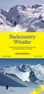
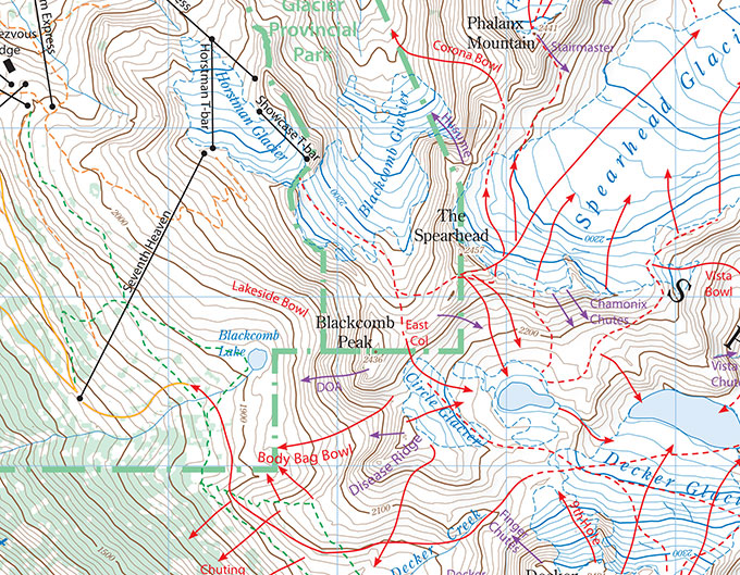
Backcountry Whistler Map
A topographic map by John Baldwin showing routes for hiking, mountaineering, backcountry skiing, steep skiing and heli-skiing in the Coast Mountains near Whistler
|
|
The Backcountry Whistler Map is a recreational topographic map for the alpine areas of the Spearhead and Fitzsimmons Ranges of the Coast Mountains of British Columbia, Canada - adjacent to and beyond Whistler and Blackcomb ski resorts. Route information for hiking, mountaineering, backcountry skiing, steep skiing and heli-skiing is marked on a large scale map and accompanied by detailed descriptions on the back of the map. The area covered contains some of the finest and most accessible alpine terrain in Garibaldi Provincial Park with extensive alpine meadows and glaciers well suited to hiking and skiing. A variety of trips into the backcountry ranging from a few hours to four or more days, in summer and winter, are described. Includes alpine hikes on Blackcomb and Whistler, the popular Singing Pass Trail and the complete Spearheads Ski Traverse.
Features:
- Waterproof, Tearproof
- Routes marked on the map for hiking, mountaineering, backcountry skiing, steep skiing and heli-skiing
- Self contained guidebook on back of the map
- 1 km UTM grid lines
- Table of slope angle relative to contour spacing
- Crevasses
- Metric conversion table
- scale 1:25,000
- contour interval 20m
- 27" X 36"
- folds to 4.5" X 10"
- full colour front and back
- waterproof and tear proof
- 14 colour photographs
- 2 route topos
- 10,000 words of text
PRICE: $25.00
Copyright © 2023-24 Backcountry Skiing Canada. All Rights Reserved.


