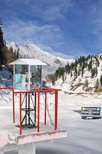
New Avalanche technology - Lasers!
It all sounds pretty Austin Powers like – but according to this article it is already in use:
Avalanches can be extremely tricky to study. Snowpack measurements have historically relied on human observations, and haven't been as accurate as snow scientists would like. Now, the Indian Snow and Avalanche Study Establishment, part of the Defense Research & Development Organization (DRDO), one of Asia's largest R&D organizations, are throwing some serious high-tech solutions at the problem. Perhaps you've heard the old nerd refrain, "Yeah, but does it have lasers?"
Yes, this avalanche-mapping device runs on lasers.
Currently installed in the Himalayas, the set-up uses "SiteMonitor" laser technology developed by 3D Laser Mapping in the UK, and was originally used to monitor gold mines in Africa. The system measures and maps the bare ground during the summer months, then tracks and maps the snow surface each day as the snowpack builds, and can measure the snowpack after avalanches to estimate how much snow was involved in the slide. The system is not just tracking depth in one small area but across a wide range, creating a data map that can be modeled in 3D to show change over the season. The state-of the art system can capture up to 1,000-point measurements per second, with an accuracy of .98 inches, and at a range of up to 3.7 miles.
According to 3D Laser Mapping, this level of repeated measurement from one location produces a detailed, season-length history of the snowpack, where day-to-day, or month-to-month comparisons can be easily and accurately made. This tool can be used to up the ante on understanding the complex dynamics of alpine snow buildup, and eventual avalanche events.
Using computers to track and forecast avalanches is not a new thing. Most national avalanche organizations use databases to log snowpack data they gather out in the field by digging snow pits and measuring snowdepth and consistency. In Europe, the Swiss Federal Institute for Snow and Avalanche Research (SWISAR) takes measurements of wind speed, wind direction, air temperature, humidity, pressure, incoming solar radiation, and reflected radiation, along with readings on the surface temperature of the snow, and readings further down into the snowpack. They have built a national computer program dedicated to tracking all this data and using it to predict avalanches.

The Himalaya project takes the SWISAR efforts a step further by introducing laser-precision snow measurements and 3-D modeling to the equation. What the ultimate outcome will be, only time will tell, but if the project is successful, it wouldn't be surprising to see a ski resort laser station paired with avalanche bombs for snow control in the near

