Powder Alert
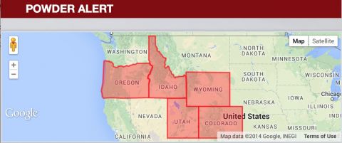
EPIC ALERTS HOISTED- OREGON, IDAHO, WYOMING, COLORADO
Summary:
EPIC alerts are rare! Heavy snow is falling over the Oregon Cascades this afternoon (7 inches in 5 hours at upper elevations). Moderate snow is falling over much of Colorado with up to 12 inches at Crested Butte (Today), and many areas of the San Juan’s. Northern Utah did best from Ogden north as we expected earlier in the week. The Northwest storm tracks across Idaho and the Tetons early in the period and eventually drops south Friday night/Saturday. Cold front will be in Southern Utah by Saturday afternoon.

Regional Pow Cast-Fluff factor high!
Northwest:
Snow continues over Oregon through Friday (9-15 inches with higher amounts-Fluff factor is high). Idaho gets the Bulls eye on Friday with 5-10 at Sun Valley (Higher amounts near Hailey) and most mountain areas near Boise and points north (4-9). This migrates to the Tetons and eventually Wasatch and Colorado – Keep reading.
Rockies:
Snow is continuing to fall this evening along I-70 with Westerly flow. Our favored areas will include Crested Butte (nabbed 10 inches today) Telluride, and some spots along I-70 from Beaver Creek to Vail Expect 7-9 inches tonight in the northern San Juan’s and 3-6 along I-70. The system from Oregon and Washington slams into the Tetons Friday/Saturday (11-16 ). POW factor high at Grand Targhee and JHMR. A secondary system over the San Juan’s forms Friday night/Saturday bringing heavy snowfall to Wolf Creek, Durango, Telluride, Silverton (7-14) New Mexico will see light snow.
Northern Utah will see an increase of snow late Friday night into Saturday morning (7-9). The cold front hung up in Wyoming and Idaho swing through the State bringing decent fluff to all areas including Park City, Canyons, Powder, Snowbasin, both Big and Little Cottonwood and very cold temps. That cold front will reach Colorado and southern Utah by mid morning Saturday (snow increasing).
Colorado gets back in the action Saturday late morning through Sunday morning. The final cold front slams into all areas of Colorado (Steamboat-Wolf Creek) bringing Statewide snowfall to most mountains (Monarch, Snowmass, Vail, Loveland, Wolf Creek, Durango etc.). Most snowfall will be ending by Sunday morning (north to south). My estimate is an additional 7-10 inches! Bluebird Powder Day on Sunday?
What a week! Rare to see cold air in so many places (Arctic Circle air pushed south by the Typhoon earlier in the week). It is even snowing just outside of Portland! I am on A-D-D powder overload.
Visit http://www.powderchasers.com for all the details and more!


