Hi Thomas,
That's a complex question with many possible factors involved and since you state that it's not even the actual slope in the image, it makes it even harder. But I'll try to help you out with the bit I've learned over the years:
-
You mentioned PWL's. I think it may be good to clarify that those PWL's you're referring to were in fact very serious instabilities with major consequences. One thing I've learned (the hard way) is to never trust surface hoar instabilities, even after they've appeared to tighten up. It's not like any other weak layer, can't stress that enough. For the most part and to generalize, the dragons of the weak layers in the Columbia Mountains are early season rain crusts (think: November crust, etc.), storm shears and surface hoar. Of course there's more but keeping it simple here, those are the main ones IMO. Usually, with appropriate time given, the rain crust issue will settle and not be an issue (not always though but usually) until spring when it once again can become a serious issue. Storm shears are overall, easily managed. We just give them a bit of time to settle & bond and usually, all is good in Kansas. As already mentioned, never fully trust surface hoar! It's the one PWL that catches even the pro's by surprise.
-
Regarding traveling more along the top or bottom, again this is pretty tough to summarize simply but a lot can depend on what type of weak layer you may be concerned about. Since the PWL's you're referring to are surface hoar layers, a common mistake is that people often think that they are less likely to trigger from the bottom of a slope. Although that's probably true for most potential weak layers, surface hoar is a unique beast. It is OFTEN triggered from the bottom of a slope. A friend and myself once triggered a Class 3.5 very far from the actual slope, thing rolled through both sides of us, continued to valley bottom and buried the Connaught uptrack. We were super lucky as we were on a small piece of slightly higher ground, that saved us. Thought we were gonners fer sure. Another time, we were causing every slope in a huge valley to release from 1/4 to 1/5km away while walking in the flat valley bottom.
-
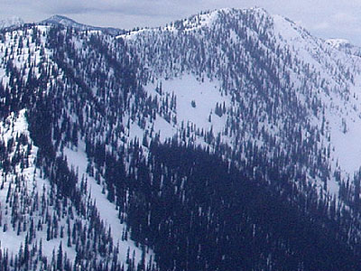
As far as trees offering protection: sure, sometimes but sometimes not at all. Especially when historic avalanches are releasing and ripping brand new avy paths through 300+ year old forest. Lots of that happened in the most recent cycle. Using the image that you posted, I'd say we're looking at some fairly complex terrain there. No easy way up that thing, regardless of what tactic is used, you'd still have to put yourself in a fairly exposed position. Also, that's like prime terrain for avalanches during such cycles (surface hoar), lots of folks think the trees will offer protection. Fact is, terrain as shown in the image is probably some of the most frightening terrain during times like that.
Sorry if I didn't answer your question as you were asking, kinda hard piecing together exactly what you were asking about as well as having just a photo to go by. Also, there's way more to this stuff than I've mentioned but years of snowpack/terrain observations just can't be summed up without writing a book about it.
One last thing I'll mention is, during times like that, using the terrain appropriate to the conditions is a really good idea!! You asked: Which is best? Stay high or go low? Considering that you guys were obviously concerned about the instabilities there, likely the best advice I could offer is: Neither, scenarios like that call for good judgment, a good time to keep it mellow, live another day, drink anutha beer, that kinda thing!!
Thanks for posting this, it's good to see people wanting to learn.
P.S. I'm not an expert so some of the stuff that I've said could be B.S. ;)
